
Step inside, please: Google launches indoor maps in UK

With millions of extra visitors expected in London later this month (there’s a rather big sporting event taking place, if you hadn’t already heard), Google’s UK launch of its indoor mapping service couldn’t have come at a better time.

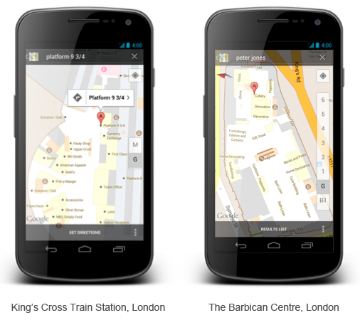
The service, which has been available for some US locations since last November, works on Android devices and provides floor plans of a number of popular London tourist spots, as well as some of the capital’s biggest department stores, train stations and airports.

Recommended Videos

Visitors to the mind-bogglingly huge British Museum – one of the largest museums in the world – are likely to find the online map of its floor plan indispensable, as will anyone wandering about the recently renovated St. Pancras International train station.

“You’ll no longer need to feel clueless when you’re at the railway station, trying to figure out where to buy a coffee before you rush to catch your train from platform 11; nor will you feel embarrassed about asking for the lingerie section when you’re in the department store – because you’ll have all the answers in the palm of your hand,” a post on Google’s Lat Long blog said.

To bring up the interior layout of a building, all you have to do is zoom in on the location using Google Maps. Once you’re in close enough, the floor plan will appear on the screen. If you enable the My Location feature, your precise whereabouts will be shown with the familiar blue dot.

Thirty-five London locations (plus five airports throughout the country) are currently mapped, though that could grow rapidly as Google has provided a link for building owners to upload their own floor plans.

With British weather known for its abundance of rain, visitors may well find themselves indoors more than out, in which case Google’s new service could prove a fabulous time saver.

Topics
Trevor Mogg
Contributing Editor
Not so many moons ago, Trevor moved from one tea-loving island nation that drives on the left (Britain) to another (Japan)…
Waze vs. Google Maps: Which one is right for you?
google v waze feat image

When you need to go somewhere, you naturally seek out the best route with the lightest traffic possible and fewest obstructions. Today's mapping and navigation apps are there for you. The two most popular apps for iOS and Android -- Google Maps and Waze -- deliver on that brief, presenting up-to-the-minute information, real-time turn-by-turn directions, and much more.

Google Maps and Waze are amongst the most popular navigation apps -- even among iPhone users -- because both are easy to use and consistently deliver accurate directions. So which one of these two Google-owned apps should you choose as your day-to-day driving navigation aid? Let's figure it out by looking at the two side-by-side, so you can see why of the two apps you prefer.
What is Waze?

Read more
New Google Maps features offer a preview of doom-conscious tech
google maps fire

If this last year felt a little more apocalypse-y than others past, it’s not without good reason. And as with every industry, tech is starting to take notice. As such, many of the new Google Maps features announced this week preview a tone shift within the industry. As technology plateaus, rather than shallow convenience, the focus appears to be transitioning to quality-of-life improvements, and hopefully, sustainability.

One element of our day-to-day lives that has undergone a begrudging transformation is grocery shopping. Once a universally beloved pastime (sarcasm), picking up the necessities in-person has been made even less convenient, and in some areas entirely inadvisable. For this reason, many of us have grown accustomed to picking up online orders or scheduling them to be delivered, and Google Maps hopes to further alleviate the new challenges this presents in a couple of ways.

Read more
Apple Maps vs. Google Maps: Which one is best for you?

Navigation tools like Google Maps and Apple Maps have changed the way we find places, explore local businesses, and share directions with friends. Both have a similar purpose, but you will find that there are some differences in their navigation tools and interfaces.

If you rely on an Android device, Google Maps is the only option of the two. However, if you own an iPhone, learning more about the differences between Google Maps and Apple Maps will help you choose the best navigation app for your needs.
Maps vs. Maps historical contest
Launched in 2005, Google Maps has been the premier mobile mapping service since the dawn of the smartphone. Apple Maps for the iPhone and iPad, on the other hand, didn't arrive until 2012 and for years it struggled with technical issues. These included wrong directions, lack of support for public transportation, and many glitches and bugs that made the service nearly unusable. All the while, Google Maps continued to improve and reign supreme.

Read more